For practices

Know what affects a site before you quote

Screen a site in minutes and send the client a sourced report. Conservation areas, listed buildings, flood risk, green belt, Article 4 directions and tree preservation orders, across England, Wales and Scotland.

3 free checks a day · No sign-up · Site report £9.99, one-off · Pro £19 a month or £190 a year

Planning ConstraintsIllustrative example
How it works

Check a site free. Get the site report when you need it.

Check a site free
Illustration with example sites and activity. Not a live result.Explore a feature ↑

What a result looks like

How results are shown

A blank on a free council or government map doesn’t tell you whether nothing is there or the data was never published. Every line here says which.

Example, England: an owner planning an extension

A house in a conservation area

  • Found

    Conservation area: inside

    Permitted development is restricted for some work here. Check before you plan cladding, windows or a side extension.

    Source: planning.data.gov.uk, published by the council

  • Found

    Listed building: next door

    A listed neighbour can affect how the council sees your design.

    Source: Historic England

  • Came back clear

    Flood Zones 2 and 3: came back clear

    Nothing mapped at the pin.

    Source: Environment Agency

  • Couldn’t check

    Tree preservation orders: couldn’t check

    The source did not answer. Ask the council’s tree officer before you remove or cut back a tree.

    Source: planning.data.gov.uk
Example, Scotland: a consultant screening before a fee proposal

A development site near Inverness

  • Found

    River flooding: medium likelihood

    About a 1 in 200 chance each year. SEPA publishes likelihood, not Flood Zone 2 or 3.

    Source: SEPA

  • Came back clear

    Scheduled monuments: came back clear

    None within the search area.

    Source: Historic Environment Scotland

  • Couldn’t check

    Tree preservation orders: couldn’t check

    Highland has not supplied this data. An empty map here would not mean there are none, so ask the council.

    Source: Improvement Service Spatial Hub, from council submissions

Examples of how a result reads. The sites are invented, and these are not live results for any address. A real check names the source for every line.

The site report · £9.99, one-off

What is in the site report

Everything we can check within 500 m of your pin, for 30 days. The report link never expires. There is no account to create.

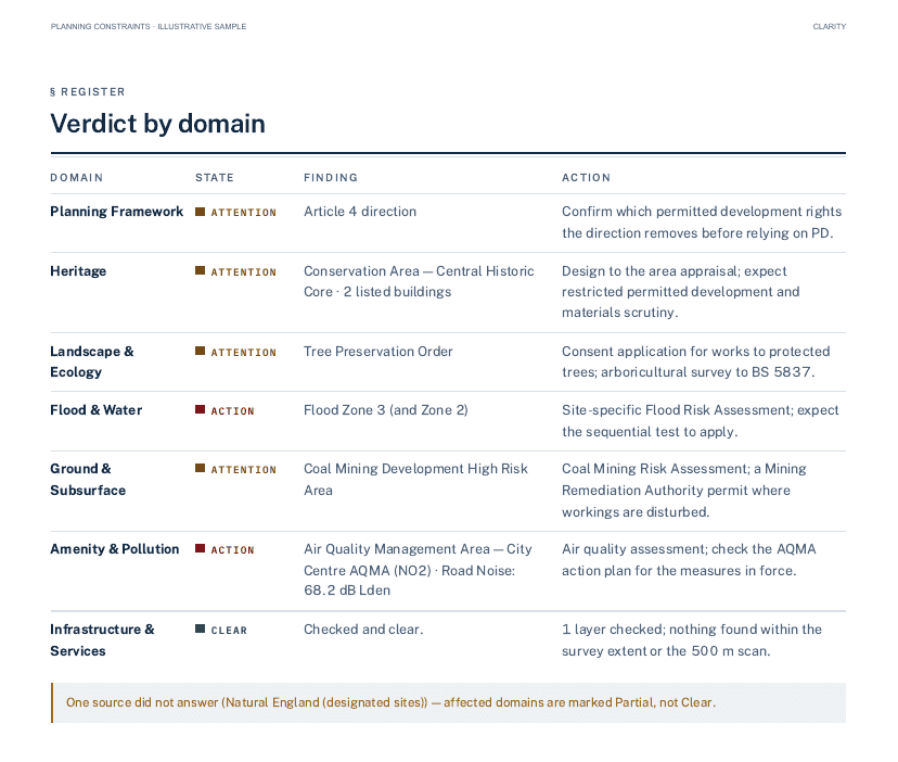
  • A verdict by domain: heritage, flood, planning framework, trees and ecology, ground, and amenity.
  • The source for every line, so you can follow it back to the publisher.
  • A scaled map of the constraints around your pin.
  • A PDF and a link you can send to a client, a council officer or a designer.
  • A plain note where a source couldn’t be checked. Those domains are marked Partial, never clear.
Page two of the illustrative sample report: a verdict by domain table with planning framework, heritage, landscape and ecology, flood and water, ground, and amenity rows, each with a state, the finding and a suggested action.
Part of one page of the illustrative sample report. The findings are invented and it is not a report on a real site.

For practices

Screen the site before you quote.

Team is £49 a month for five people, with one shared pipeline of sites. Month to month, with a VAT invoice, and you can cancel at any time. When someone leaves their access ends, and the firm keeps the sites.

  • Your practice's logo, name and colour on the reports you send
  • A PDF report and a hosted link for the client
  • A scaled map figure for your drawings and proposals
  • A shared pipeline, five sign-ins and free read-only guests for clients
  • Area watches for new applications in England, and land assemblies
Five seats · £49 a month · VAT included

Illustrative workspace. Example sites, colleagues and activity.

Coverage

Coverage in England, Wales and Scotland

Each nation has its own rules and publishers. Where a nation has no equivalent, we say so rather than show an empty line.

NationWhat we checkWhat to know
EnglandHeritage, flooding, green belt, Article 4 directions, tree preservation orders, ecology designations and ground risks, with the NPPF as the policy context.Some councils don’t publish every dataset. The result says when a source couldn’t be checked, so ask the council where it matters.
WalesHeritage from Cadw, flooding under TAN15 (the Flood Map for Planning), nature designations and Planning Policy Wales.Wales has no green belt, and no national Article 4 or tree preservation order data is published, so those are shown as not covered in Wales.
ScotlandHeritage from Historic Environment Scotland, flood likelihood from SEPA, nature from NatureScot, NPF4 and local development plans.There is no Flood Zone 2 or 3 in Scotland. Green belt, tree preservation orders and Article 4 come from council submissions to the Improvement Service Spatial Hub. Where a council hasn’t supplied them, or the source can’t be reached, the report says so rather than showing clear.
Northern IrelandNot covered.We don’t serve Northern Ireland.

Sources and licences →Every check, by nation →

Pricing

What it costs

Every paid report includes all the constraint checks we support. Pro is for repeat work and adds planning applications.

Site report

One site

£9.99one-off

Everything we can check within 500 m of your pin, for 30 days. The report link never expires.

  • Every line sourced
  • Buy it from your free result
See a sample report

Pro

For one person doing regular site work

£19a month

Up to 200 saved sites, anywhere in England, Wales and Scotland

  • Month to month
  • Cancel at any time
See Pro

All prices include VAT. Coverage varies by nation, location and source, and some councils don’t publish every dataset. Planning Constraints is a screening tool, not an official search, a CON29 or an LLC1, and not professional advice. Check anything important with the local planning authority before you act.

Who builds it

Built in Derby by Broadhurst Digital.

Martin Broadhurst builds and runs Planning Constraints. The data comes from official sources, and every one is listed with its licence.

About us →Talk to us →