How to Find Planning Constraints for Any UK Property
A step-by-step guide to checking planning constraints before buying land, submitting a planning application, or starting a development project in England.
If you're buying a property, developing land, or simply curious about what restrictions apply to a site, the first thing you need to do is check the planning constraints. This guide explains what planning constraints are, why they matter, and how to find them for any location in England.
What are planning constraints?
Planning constraints are designations, policies, and environmental factors that restrict or influence what you can do with a piece of land. They come from many sources — local planning authorities, national government, historic and environmental bodies — and they can affect everything from whether you can build an extension to whether a site is suitable for development at all.
Common examples include:
- Conservation areas — areas of special architectural or historic interest where development is more tightly controlled
- Listed buildings — structures of special interest that cannot be altered without listed building consent
- Flood zones — areas at risk of flooding from rivers or the sea
- Green belt — land around towns and cities where development is heavily restricted to prevent urban sprawl
- Tree preservation orders (TPOs) — individual trees or groups of trees that cannot be cut down without permission
- Sites of Special Scientific Interest (SSSIs) — areas protected for their wildlife, geology, or other natural features
Why do planning constraints matter?
Constraints do not necessarily prevent development, but they do shape what is possible. A conservation area means your design needs to be sympathetic to local character. A flood zone means you may need a flood risk assessment. Green belt means the presumption is against development unless very special circumstances apply.
For buyers, knowing the constraints upfront helps you understand the real value and potential of a property. For developers and architects, it determines the scope of what can be proposed and the level of scrutiny a planning application will receive.
Discovering constraints late in the process can cause delays, additional costs, or outright refusal.
Method 1: Use our free online tool
The fastest way to check planning constraints is to use our Planning Constraints Map. It queries official government datasets in real time and shows you every known constraint within 500 metres of your chosen point.
How to use the tool
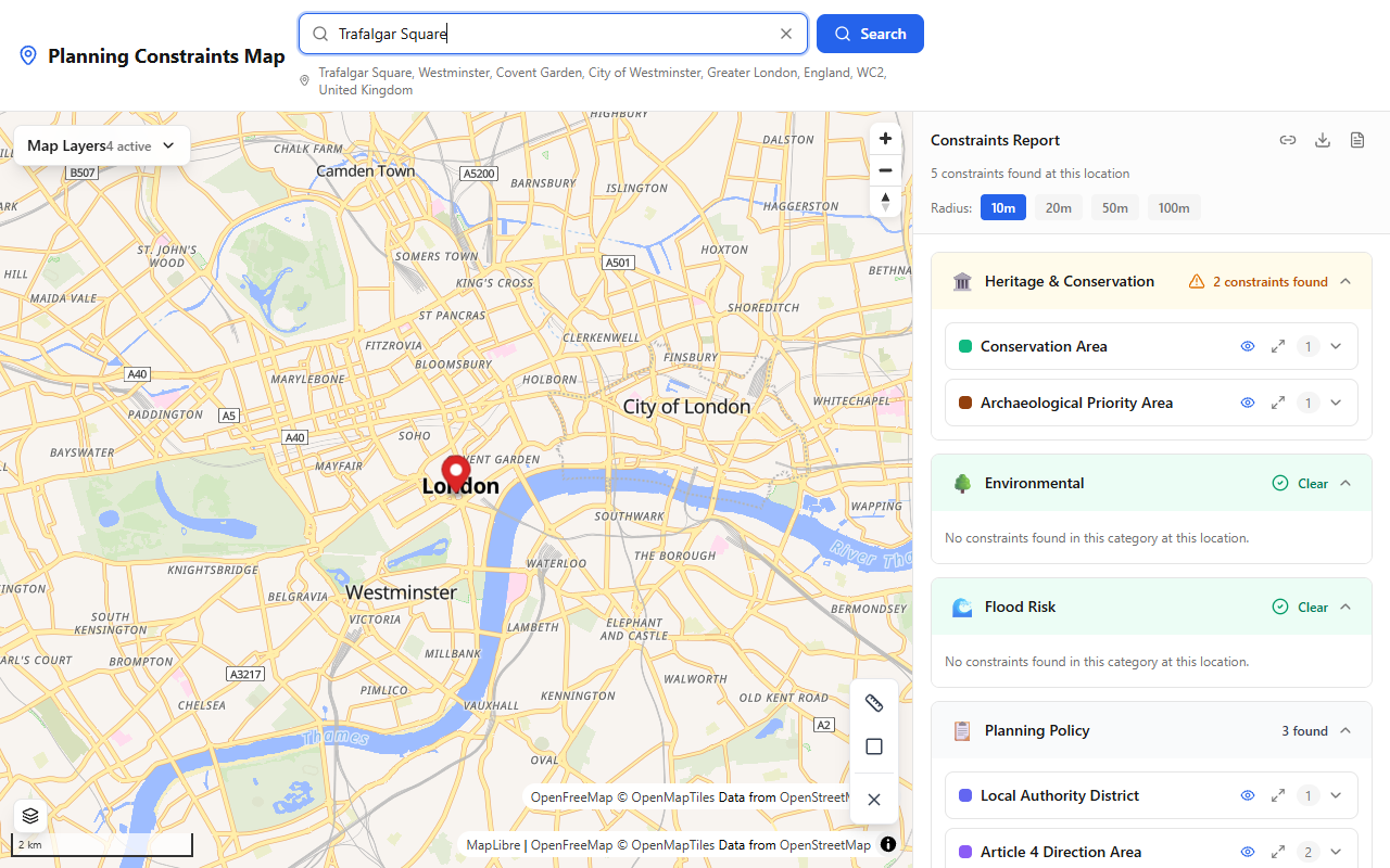
The Planning Constraints Map showing heritage, environmental, flood risk, and planning policy constraints near Trafalgar Square, London.
- Go to the map — Open the tool in your browser
- Search for a location — Type a postcode, address, or coordinates into the search box, or click directly on the map
- Review the results — The panel on the right (or bottom on mobile) shows every constraint found, grouped by category
- Explore boundaries — Constraint boundaries are drawn on the map so you can see exactly where designations start and end
- Generate a report — Download or share a PDF report for your records
The tool checks over 30 constraint datasets from official sources including planning.data.gov.uk, Historic England, Natural England, and the Environment Agency.
Method 2: Check your local planning authority's website
Every local planning authority (LPA) in England maintains a constraints map or "policies map" as part of its Local Plan. These are usually available online, though the quality and ease of use varies significantly between councils.
Search for "[your council name] planning constraints map" or "[your council name] policies map" to find it. Some councils use dedicated GIS (mapping) platforms, while others publish static PDFs.
The advantage of the LPA map is that it may include locally specific constraints — like areas covered by Article 4 directions or locally listed buildings — that aren't always captured in national datasets.
Method 3: Order a planning constraints search
For formal transactions like property purchases, your solicitor will typically order a Local Authority Search (also called a CON29 search). This is a paid service where the council provides an official written response confirming which constraints apply to a specific property.
This is the most authoritative method, but it can take several weeks and costs between £100 and £300 depending on the council. It's primarily used during conveyancing rather than for early-stage research.
Method 4: Check individual data sources directly
You can also check individual datasets yourself:
- Conservation areas, green belt, TPOs, Article 4 directions — planning.data.gov.uk provides a national search for many constraint types published by local authorities
- Listed buildings and scheduled monuments — Search the National Heritage List for England maintained by Historic England
- Flood zones — Use the Environment Agency's Flood Map for Planning
- Ancient woodland and SSSIs — Check Natural England's MAGIC Map
This approach is free but time-consuming, since you need to check multiple sources separately.
What to do once you know the constraints
Once you know which constraints apply, the next step depends on your situation:
- Buying a property — Factor constraints into your offer price and plans. A house in a conservation area may have restricted permitted development rights. A site in a flood zone may have higher insurance costs.
- Planning an extension or alteration — Check whether you need planning permission (some permitted development rights are removed in conservation areas and by Article 4 directions) or listed building consent.
- Developing a site — Commission specialist reports as needed (heritage impact assessment, flood risk assessment, ecological survey) and discuss the constraints with your local planning authority at a pre-application meeting.
Summary
Checking planning constraints early saves time, money, and frustration. Our free tool gives you instant results from official data sources — try it now to see what constraints apply to your site.
Survey your own site — free
See every planning constraint at any UK address in seconds: conservation areas, listed buildings, flood zones, Article 4 and 30+ more. Need it on paper? The Full Survey Report with plain-English guidance is £9.99.