10 Things Open Planning Data Can Tell You Before You Buy a Property
What free government open data can reveal about a property before you make an offer — from flood risk and heritage designations to green belt and ecological constraints.
Check all of these in 10 seconds — search any address on PlanningConstraints.com for instant constraint results from official government data. Free, no sign-up.
You would not buy a car without checking its history. The same logic applies to property — except the "history" that matters most is often about what the land is designated as, not what the building looks like.
Free government open data can tell you a surprising amount about a site before you even arrange a viewing. Here are 10 things you can find out.
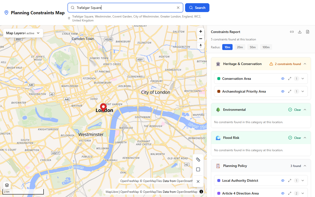
A single search on PlanningConstraints.com reveals conservation areas, flood risk, heritage designations, and planning policy constraints.
1. Whether the property is in a conservation area
Conservation areas have stricter planning controls. Permitted development rights are reduced, meaning work that would normally be allowed (like certain extensions, cladding, or demolition) may require a planning application. This is not necessarily bad — conservation areas are often desirable places to live — but it affects what you can do.
Source: PlanningConstraints.com or planning.data.gov.uk
2. Whether the building is listed
A listed building cannot be altered internally or externally without listed building consent. This includes things as small as replacing windows or moving an internal wall. If you are buying a listed property with plans to renovate, you need to know this before you commit.
Source: PlanningConstraints.com or Historic England's National Heritage List
3. Whether the site is in a flood zone
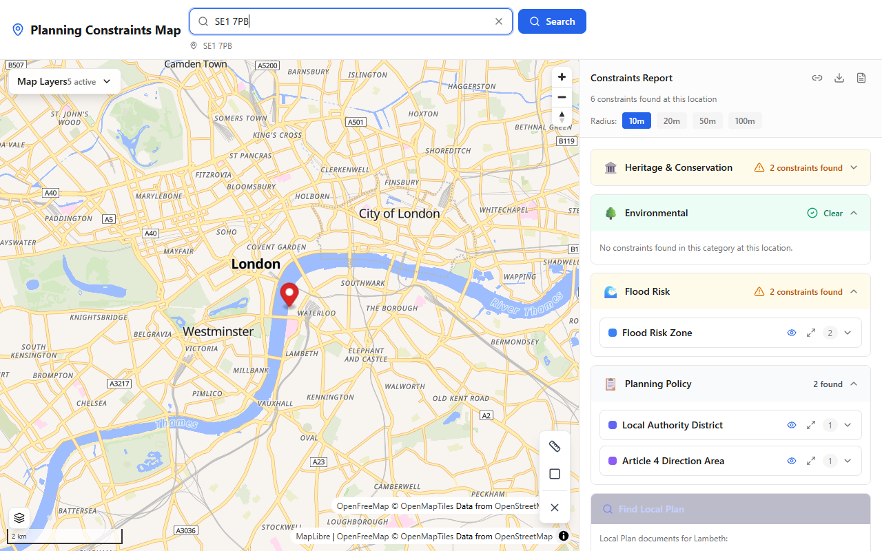
Flood Risk Zone results shown instantly on PlanningConstraints.com.
Flood Zone 2 and Flood Zone 3 designations indicate medium and high probability of flooding respectively. This affects insurance costs, mortgage availability, and any future development plans. Even if the property has never flooded, the flood zone classification matters for planning and finance.
Source: PlanningConstraints.com or the Environment Agency Flood Map for Planning
4. Whether the land is green belt
Green belt status severely limits what can be built on the land. If you are buying with the intention of extending, building an outbuilding, or developing the site, green belt is one of the most important things to check. The presumption is against development unless very special circumstances apply.
Source: PlanningConstraints.com or planning.data.gov.uk
5. Whether there are tree preservation orders
Protected trees on or adjacent to the property can constrain development, restrict what you can do in the garden, and create maintenance obligations. Removing a protected tree without consent can result in unlimited fines.
Source: PlanningConstraints.com or your local council's tree officer
6. Whether the site is near a SSSI
Sites of Special Scientific Interest are protected for their wildlife, geological, or other natural features. Development near a SSSI that could affect the site may require an ecological assessment, and Natural England must be consulted. This can add time and cost to the planning process.
Source: PlanningConstraints.com or Natural England's MAGIC Map
7. Whether Article 4 directions apply
Article 4 directions remove specific permitted development rights in a defined area. This means work that would normally not need planning permission — like converting a house to an HMO, or changing certain commercial uses — suddenly requires a formal application. These are easy to miss if you do not check.
Source: PlanningConstraints.com or planning.data.gov.uk
8. Whether the property is near a scheduled monument
Scheduled monuments are nationally important archaeological sites with the highest level of protection. Works affecting a scheduled monument — including anything within its curtilage — require scheduled monument consent from Historic England. This can affect gardens, boundaries, and ground works.
Source: PlanningConstraints.com or Historic England's National Heritage List
9. Which local authority manages planning
This tells you which council will determine planning applications, which Local Plan policies apply, and where to find the relevant planning department. In areas near council boundaries, it is not always obvious which authority has jurisdiction.
Source: PlanningConstraints.com shows the Local Authority District for any searched location
10. Whether the area is an AONB or National Landscape
Areas of Outstanding Natural Beauty (now called National Landscapes) have stricter planning policies similar to National Parks. Major development is only permitted in exceptional circumstances. Even smaller-scale development faces higher design standards and greater scrutiny.
Source: PlanningConstraints.com or Natural England's MAGIC Map

A full Planning Constraints Report generated from PlanningConstraints.com — showing detailed constraint data for a specific location.
Do your homework before you make an offer
All of this information is available for free through government open data. The question is whether you check it before or after you have committed to a purchase.
A solicitor's Local Authority Search (CON29) will eventually cover most of this ground, but that typically happens after you have already agreed a price and paid for surveys. By then, pulling out is expensive.
PlanningConstraints.com lets you check all of these constraints in seconds — before you even book a viewing. Enter a postcode, see the results, and make an informed decision.
Survey your own site — free
See every planning constraint at any UK address in seconds: conservation areas, listed buildings, flood zones, Article 4 and 30+ more. Need it on paper? The Full Survey Report with plain-English guidance is £9.99.